Mt. Everest Expedition ~ Mount Everest Expedition ~ Everest expedition information
Some climbers climb this mountain on their own risk without any climbing Sherpa guide; and some climbers go with their own climbing Sherpa guide. Most of the teams carry own their on Internet, Satellite phone, Medical doctor and rest of the modern requirement. After the Base camp, we have to cross crevasses, Sercs and ice black. Similarly we should face to the way up having Chunks of ice as large as our houses where we should used fixed ropes and aluminum ladders to climb ahead camp 1st 6400m.
Camp 1: 20000ft. (6,400m.)
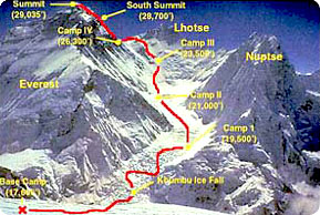 This camp 1 is situated at the flat area of snow endless snow deep crevasses and mountain walls. Because of the Sun's reflection from this place we get warm and hitting ambience at this place. In the night we listen the deep murmuring cracking sounds of crevasses beneath our tent. These are the areas where we have to walk to reach camp 2.
Camp 2. 21000ft. (6,750m.)
This camp 2 is situated at the height of the 21000ft, which is located at the foot of the icy Lhotse wall though where we have to go ahead. Whether is here is good but bad clouds roll in from the low range of the Himalayan valleys to the bottom of our camp two. But wind here some times seems very violent enough to destroy our tents. After climbing these palaces we reach
Camp 3. 22300ft. (7,100m.)
Camp 3 is located at the height of 22300ft, adjoining to Lhotse wall. After climbing the 4000ft. Lhotse wall by using fixed rope and with prior acclimatization it leads us to camp 4. Also on the way we have to ascend the steep allow bands (lose, down -slopping and rotten limestone). From their crossing short snowfield the route moves ahead up the Geneva Spur to the east before finishing the flats of the south col. (Another wells name meaning Saddle of pass). Oxygen should probably be use above base camp 3 incase of needed to the climbers.
Camp 4. 26000ft. (8,400m.)
Now are on at camp 4 which located height of 26000ft; it is the last camp of the Expedition. From here summit is about 500m, distance far. This is the final and dangerous part of the climbing. This place is besieged by ferocious and violent winds. The normal best way to reach to summit is via the narrow South -East Ridge and it precedes the South Summits 28710ft. From here the way is easy to reach at the summit of the Everest 29028ft; and Sir Edmond Hillary and late Tenzing Norge Sherpa used this route in 1953.
Everest Expedition Itinerary
Day 01:
Arrival Kathmandu. Transfer to hotel.
Day 02: Kathmandu for official procedure.
Day 03: Kathmandu official procedure.
Day 04-05: Fly to Lukla (2800m) and trek to Phakding (2640m). Overnight at
Day 06: Namche Bazaar (3446m). Overnight in lodge.
Day 07: Khumjung (3790m). Overnight at
Day 08: Khumjung, acclimatization day.
Day 09: Tengboche Monastery (3867m). Overnight in lodge.
Day 10: Pheriche. Overnight in lodge.
Day 11: Lobuche (4900m). Overnight at
Day 12: Rest day in Lobuche
Day 13: Everest Base Camp.
Day 14-57: Climbing Period Mt. Everest.
Day 58: Cleaning up Base Camp.
Day 59: Pheriche. Overnight in lodge.
Day 60: Khumjung.
Day 61: Trek to Phakding.
Day 62: Trek to Lukla. Overnight in lodge.
Day 63: Fly to Kathmandu. Transfer your hotel.
Day 64: Kathmandu Sight seeing & farewell Diner
Day 65: Back to onward destination
65 Days Mt. Everest Expedition (8848m.)
67 Days Mt. Kanchanjunga Expedition (8586m.)
55 Days Mt. Lhoste Expedition (8516m.)
59 Days Mt. Makalu Expedition (8463m.)
48 Days Mt. Cho -oyu Expedition (8201m.)
58 Days Mt. Manaslu Expedition (8167m.)
56 Days Mt. Dhaulagiri Expedition (8163m).
55 Days Mt. Annapurna Expedition (8091m.)
40 Days Shishapangma Expedition (8013m.)
35 Days Mt. Pumori Expedition (7161m.)
36 Days Mt. Kantega Expedition (6779m.)
34 Days Langtang Lirung Expedition (7234m.)
43 Days Barunste peak Expedition (7129m.)
30 Days Ama Dablam Expedition (6856m.)
54 Days The Nupste Expedition (7855m.)
P.O.Box No: 21235,Thamel, Kathmandu, Nepal
Tel: +977 1 4383184, Fax: +977 1 4415679
Cell: +977 98510 07829
E-mail: himjourney@mail.com.np
We are affiliated with Nepal Tourism Board, Government of Nepal, Tourism Ministry, TAAN, NMA, KEEP, HRA and STN.
![]()
![]()
![]()
![]()
![]()
![]()
![]()
![]()